St Helens Borough Local Cycling and Walking Infrastructure Plan (LCWIP)
What are the outcomes of the LCWIP for cycling?
The proposed network of new cycle infrastructure includes infrastructure interventions from upgrades of streets to be more cycle-friendly to fully protected cycle routes.
The aim is that all new infrastructure will allow cycling to be accessible to all who are able.
Integration of the St Helens LCWIP and Liverpool City Region LCWIP
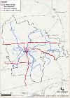
The cycling elements of the St Helens Borough LCWIP (PDF, 14 MB) has been developed within the context of the Liverpool City Region LCWIP, adding local links to this planned regional network.
As shown on the map below (click to enlarge), the new or upgraded cycling links (in blue) will connect the urban areas within the borough into the Liverpool City Region network (in red).

Proposed Cycling Schemes:
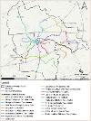
The map below (click to enlarge), shows the individual schemes to be developed as part of the St Helens Borough LCWIP.

Currently, we are working on a selection of schemes from our LCWIP. To find out more about one of the routes please clicks their links.
• Active travel proposed route: Lea Green to Whiston Hospital
• Active travel proposed route
• Active Travel proposed route: A580 East Lancashire Road
Full details of the network development process and the schemes shown are available inLCWIP Plan (PDF, 14 MB)


