St Helens Borough Local Cycling and Walking Infrastructure Plan (LCWIP)
What is the St Helens Borough LCWIP?
The St Helens Borough Local Cycling and Walking Infrastructure Plan (LCWIP) (PDF, 14 MB) is our long-term plan, aimed at dramatically improving the safety, comfort and attractiveness of walking and cycling in the borough.
The purpose of this plan is to set out a prioritised list of schemes for delivery over the next 10 years that will improve walking and cycling infrastructure for St Helens Borough residents, workers and visitors alike.
To do this:
- We looked at what's already there, what the barriers were and what had potential for improvement.
- We identified connections which people use frequently and made a list of schemes to bring about improvement. This included new routes and improvements to existing routes.
- Finally, we prioritised based on things that are important to St Helens, such as improving links to education, improving road safety and reducing carbon emissions.
A great deal of research has helped inform the development of the plan, alongside a 6-week public consultation on the Draft LCWIP, before the final LCWIP was adopted by Cabinet on April 2023.
Why have we developed an LCWIP?

We want walking, wheeling, and cycling to be the first choice for short everyday trips and as part of longer-distance journeys using public transport - but for this, people need suitable and safe routes to use. Across the borough, we want to improve our roads, footways, and cycleways so that people of all ages and abilities can walk and cycle from where they live to where they want to go. By improving access to key destinations within the borough, we aim to support equal mobility for all and to enable growth for local businesses.
All this is brought together in our objectives, which have focused our decisions at every stage of our LCWIP:
| Healthy people | Inclusive community | Supporting a stronger economy | Supporting net zero |
|---|---|---|---|
| Walking and cycling for transport is an easy way to build exercise into daily life. Research has shown that regular moderate exercise can improve both physical and mental wellbeing. | Walking is the most affordable mode of transport and cycling costs are relatively low compared to other transport modes. As such, these modes are affordable to most, if not all, income groups. | Making the walking envionment more pleasant around areas has been shown to have a beneficial economic effect on local businesses. | Enabling modal shift from cars to active modes is essential to help achieve a net-zero carbon borough by 2040. |
Photo credit: Chris Foster/Sustrans. Photos are taken from the Liverpool City Region Walking and Cycling Index 2021, published by Sustrans in partnership with Liverpool City Region
What are the outcomes of the LCWIP for walking and wheeling?
We have focused improvements in three areas of the borough with some of the highest footfall: St Helens Town Centre, Earlestown Town Centre and Haydock Industrial Park.
St Helens Town Centre
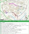
As shown on the map below (click to enlarge), walking interventions for St Helens Town Centre range in type and cover most of the streets in the Core Walking Zone.
These proposals align with the adopted Town Centre Masterplan Development Framework adopted by the council in February 2022.
The aim of the proposals is to:
• Create a pedestrianised route from St Helens Central railway station and the Stadium through the town centre to St Helens College.
• Reduce traffic circulation and movement, this is achieved by rationalising bus movements within the town centre, whilst still supporting bus, taxi and cycle movements (as well as off-peak deliveries).
Full details of the network development process and the schemes shown are available in the St Helens Borough LCWIP (PDF, 14 MB).
Earlestown Town Centre
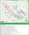
As shown on the map below (click to enlarge), walking interventions for Earlestown Town Centre range in type and cover most of the streets in the Core Walking Zone.
These align with the Earlestown Town Centre Masterplan.
The aim of the proposals is to:
• Create a pedestrianised route from Earlestown railway station through the town centre.
• Expand the existing pedestrian zone.
• Simplify the one-way system and improving bus movements.
Full details of the network development process and the schemes shown are available in the St Helens Borough LCWIP (PDF, 14 MB).
Haydock Industrial Park
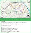
As shown on the map below (click to enlarge), walking interventions for Haydock Industrial Park cover most of the streets in the Core Walking Zone.
The aim of the proposals is to:
• Upgrade the existing Public Rights of Way.
• Upgrade and widen footways.
• Improve the existing crossings of the A580 and M6.
Full details of the network development process and the schemes shown are available in the St Helens Borough LCWIP (PDF, 14 MB).
What are the outcomes of the LCWIP for cycling?
The proposed network of new cycle infrastructure includes infrastructure interventions from upgrades of streets to be more cycle-friendly to fully protected cycle routes.
The aim is that all new infrastructure will allow cycling to be accessible to all who are able.
Integration of the St Helens LCWIP and Liverpool City Region LCWIP
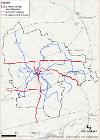
The cycling elements of the St Helens Borough LCWIP (PDF, 14 MB) has been developed within the context of the Liverpool City Region LCWIP, adding local links to this planned regional network.
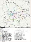
As shown on the map below (click to enlarge), the new or upgraded cycling links (in blue) will connect the urban areas within the borough into the Liverpool City Region network (in red).
Proposed Cycling Schemes:
The map below (click to enlarge), shows the individual schemes to be developed as part of the St Helens Borough LCWIP.
Currently, we are working on a selection of schemes from our LCWIP. To find out more about one of the routes please clicks their links.
• Active travel proposed route: Lea Green to Whiston Hospital
• Active travel proposed route
• Active Travel proposed route: A580 East Lancashire Road
Full details of the network development process and the schemes shown are available inLCWIP Plan (PDF, 14 MB)
When will the infrastructure be delivered?
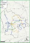
The St Helens Borough Council LCWIP (PDF, 14 MB) sets out timescales for the rollout of priority schemes in the short term (2023-2026), medium term (2026-2029) and long term (2029+).
Schemes were ranked based on numerous metrics which align with the LCWIP objectives. They were then assigned a proposed delivery timescale based on their score, accounting for deliverability constraints.
The delivery timescales of the proposed interventions are shown on the maps below (click to enlarge).


Full details of the prioritisation process and the schemes shown are available in the St Helens Borough LCWIP (PDF, 14 MB)


